A better map....
Here is a photo of a section of my Nelles map of the Himalaya. It is not a perfect map (as we found while out there in the world :) but it is better than anything else I found on the web. Click on the map and it will take you to the full size image in PhotoBucket (in a separate window, so you can look at the map and read my text :).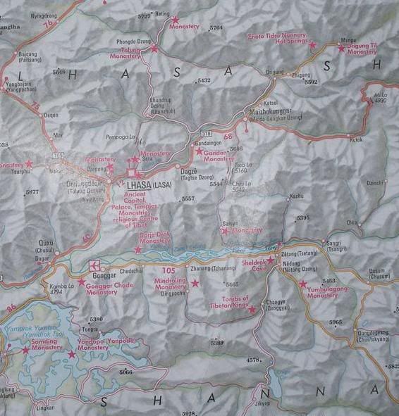
Find Lhasa in the middle. Head out of town to the east north east and you will find a pink star and "Ganden Monastery". Ganden is on the "big" road, in orange, on the east side of the river - we rode the white road on the west side of the river.
Almost directly across from Ganden you will see the white road fork to the north west - that is the road we took to Lhundrub Valley (which is marked on the map as "Lhundrup" but it is known locally as Linzhou - the Chinese name for it). We camped about 10kms to the east of town the first night.
The second day we followed the wrong road (one that is not even on the map and hence our navigational problem - it looks like there is only one road on this map so we followed the only road we found :) and went directly west of Lhundrub across the valley, we ended up turning around and coming right back and finding our second, amazing, campsite (our luck was exceptional :) just north of Lhundrub.
The third day we awoke to more snow in the high country (after our second night of rain) and we had to admit that crossing a pass that we were told is 5000m when it was looking very much like the snowline was 4500m was not the smart choice - the weather coming in was also not pretty. We changed our plans and headed back down to the Lhasa River - to the the fork across from Ganden - and decided to take a left and head northeast along the river, still on the white road. The road below the fork had been paved, but the road above the fork was dirt, but a nice solid dirt road :)
We rode about 20kms up the dirt road when we spotted what looked to be an ideal place for a campsite on the old road that we had been following along the valley - evidence of a past history of flooding. It looked high enough off the road to hide the tent from the roadway so we went up for a look and found the road to be in a bit of a trough - just the perfect width for the tent and we were well hidden from the road (again, brilliant luck in a campsite!).
The next day we continued northwest on the white road to get to the bridge to take us to the other side of the river and to a big-ish town called Medro Gunkar (what looks like Maizhokunggar on the map) - we wanted some restaurant food and we needed fuel for the stove. Our quarryman visitor from the night before had told us it was only 2kms up the road but the bridge was nearly 20kms up the road and about 5kms north of Medro Gunkar with a 5km ride back down into town - not what the map indicates at all! I am not dissing Nelles - the Chinese build roads rapidly and both the road across the valley and the bridge we quite new constructions.
As we rode into Medro Gunkar (starving :) we passed what looked like a proper campground...we didn't think they existed, but we were happy that it looked to be so - there were 3 Tibetan Tents set up and we also saw another dome tent. We were more interested in food than in checking it out :) so we headed into town and then we came back to it. We rode up to a group at one of the Tibetan tents that looked like they were having a very good time (if you can judge that by the number of empty beer cans around them on the ground :) and A pointed to our tent and the guy waved his arm around the place which we took as an affirmative (our communications are getting better everyday :).
We rode off into the scrub/yak pasture to the edge of the river (this is the river that goes directly east and a bit south of Medro Gunkar, not the Lhasa River) and found a nice protected area and promptly set up our tent. The guy that had welcomed us came to check on us and smiled...and didn't ask for any money :) Suffice it to say that we liked the place so much we stayed 3 nights :) We had many visitors, from yak herdsmen to families.
When it was time to head back towards Lhasa we headed back up the road to the bridge we crossed a few days earlier and hammered the white road back towards Lhasa. We thought it would take 2 days - it being about 90kms - but we had good legs and we were back in a day.
Find Lhundrub on the map and look at the road going north to Talung Monastery - that is the road that we wanted to take, with the 5000m pass. When you get to Talung you can see a very small pink road going east south east to join up with the white road that we were riding. The plan is to do a reverse loop - ride back to Medro Gunkar and connect up with that small pink road, ride to Talung Monastery and then take that white road south, up over the pass back, back to the Lhundrub Valley and then back to Lhasa. We really want to ride that pass :)
I hope you enjoyed this cartographic experience :)
posted by Kellbell at 10:40 am
![]()